

Showing posts with label tekong. Show all posts
Showing posts with label tekong. Show all posts
07 October 2026
Study into energy infra on Pulau Tekong reclaimed land
A 200ha site on reclaimed land at Pulau Tekong is being studied for a possible energy infrastructure cluster. Comprising hydrogen-ready natural gas-fired power plants, a liquefied natural gas (LNG) terminal and other low-carbon energy technologies. A consultant is expected to be appointed by mid-2027 for the 2-year study.
 Singapore currently relies on imported natural gas for 93% of its energy needs and produced about 13 gigawatts of electricity in the first half of 2025. The study will look into generating 6 gigawatts of domestic power generation and 2 gigawatts of electricity imports via three designated sea corridors. There are currently 13 electricity import projects in the works, with a combined capacity of more than 9 gigawatts. The projects cover solar, wind and hydropower from Malaysia, Indonesia, Cambodia, Vietnam and Australia. The study will also look into accommodating nine to 15 telecommunication submarine cables via three to five designated sea corridors connecting to the area within Pulau Tekong.

04 March 2025
Reclamation for a bigger Pulau Tekong
Plans to build a bigger Pulau Tekong have been in the works through a land reclamation project.
 The expansion "to stretch 10km in distance" will serve as a training area for soldiers and combat vehicles.

28 March 2019
Pulau Ubin and northern shores in the 2019 Draft Master Plan
It appears the plan is for the northern coastline to remain rustic: from Sungei Buloh to Changi. It includes reassuring references to continued presence of wild mangroves at Pasir Ris and Khatib Bongsu; and Chek Jawa is mentioned as "one of Singapore's richest ecosystems".
At Pulau Ubin, there is now no areas designated for agriculture use. But the reclamation profile on Pulau Ubin remains unchanged. And I remain worried about the Round Island Route which skirts close to the shoreline, particularly the area at the eastern tip of Pasir Ris Park and along the Changi coast.
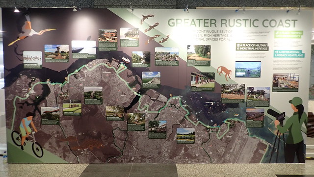 |
| Illustrative panel of the Greater Rustic Coast at the Draft Master Plan exhibition. |
11 July 2018
Ferry runs aground on reclaimed land at Tekong 9 July 2018
A ferry carrying 45 people was stranded on reclaimed land near Pulau Tekong during low tide after it collided with rocks along the island on 9 Jul 2018 near midnight. Visibility was low and the ferry was at risk of capsizing.
All on board were rescued by the Police Coast Guard. There were no reports of injury or oil pollution, said MPA, adding that the owner is making arrangements to "re-float" the ferry.
Related media articles
 |
| Graphics from The Straits Times, 10 Jul 18 |
 |
| Photo from the Singapore Police Force in The New Paper, 11 Jul 18 |
Related media articles
16 May 2012
Pollutive petrochemical plant may be relocated near our Northern shores
A petrochemical complex that was rejected in Taiwan for environmental and health reasons may be relocated to Pengerang, Johor.
 Rich shores in the vicinity include Chek Jawa on Pulau Ubin, Singapore's best natural mangroves on Pulau Tekong, our best northern submerged reef Beting Bronok and Changi's seagrass meadows.

06 May 2012
Huge blaze reported near Pulau Tekong
This just posted in the media: A huge blaze on a piece of reclaimed land between Singapore and Pulau Tekong. The fire is not on Tekong. The only people on 'the island' are land reclamation workers. The fire started at 2.15pm and is reportedly ongoing.
Important natural areas on and near Tekong include Singapore's best natural mangroves and our best northern submerged reef Beting Bronok.
 |
| from AsiaOne, from Stomp |
25 May 2011
Massive reclamation at Pulau Tekong continues
The massive reclamation at Pulau Tekong that has been going on for years, will continue until end of 2011. The shores nearby include Chek Jawa, Beting Bronok and Changi (links are to photo sets on wildsingapore flickr).
What is the ultimate purpose of all this reclamation?
 The shores nearby include Chek Jawa, Beting Bronok and Changi (links are to photo sets on wildsingapore flickr).
What is the ultimate purpose of all this reclamation?
14 May 2011
'Massive oil-gas hub' planned in Pengerang, Johor
About 1,000ha of coastal land off Singapore's eastern coast has been earmarked for the development of the RM60 billion (S$24.9 billion) Refinery and Petrochemical Integrated Development (Rapid) complex.
 "One of the reasons why Pengerang was chosen is because its waters can reach depths of more than 20m, which is what is needed for very large crude carriers (VLCC) and ultra large crude carriers." The first phase of the project is expected to come on-stream in 2016.

06 January 2011
Saving mangroves at Pulau Tekong continues!
Efforts to save more than 1,000 mangrove trees on Pulau Tekong's north-eastern coastline continue! These trees are at risk from serious erosion due to boat traffic.
This never-before-attempted approach to coastal protection and restoration is being tried out by NParks to save possibly the last largest pristine stretch of mangroves in Singapore. It's good to hear that the efforts are on-going in a recent MPA Port Marine Notice. More about this effort.
 |
| From the Straits Times. Click on image for larger view. |
09 September 2010
7.5 million population: what it means for Chek Jawa and Ubin
It will "not make a huge difference" if Singapore's population were to grow to 7.5 million as "there are still the islands of Pulau Ubin and Pulau Tekong to fall back on". This is what Dr Liu Thai Ker, former CEO of HDB and URA, is reported to have said when asked what he thought was the "appropriate size" for Singapore's population.
 In fact, the book The Next Lap shows the above plan for Ubin and Tekong. It shows industry (in pink) and high density housing (in orange) on both islands, with an MRT line (in red) from the mainland (extending the line which now ends at Pasir Ris).
 In fact, the book The Next Lap shows the above plan for Ubin and Tekong. It shows industry (in pink) and high density housing (in orange) on both islands, with an MRT line (in red) from the mainland (extending the line which now ends at Pasir Ris).
21 May 2010
Massive reclamation at Pulau Tekong continues until Dec 10
The massive reclamation at Pulau Tekong that has been going on for years, will continue until end of 2010.
 The shores nearby include Chek Jawa, Beting Bronok and Changi (links are to photo sets on wildsingapore flickr).
What is the ultimate purpose of all this reclamation?
 The shores nearby include Chek Jawa, Beting Bronok and Changi (links are to photo sets on wildsingapore flickr).
What is the ultimate purpose of all this reclamation?
12 May 2010
Saving Singapore's last best mangroves at Pulau Tekong
A never-before-attempted approach to coastal protection and restoration is being tried out by NParks to save possibly the last largest pristine stretch of mangroves in Singapore.
More than 1,000 mangrove trees on Pulau Tekong's north-eastern coastline are at risk from serious erosion due to boat traffic.
More than 1,000 mangrove trees on Pulau Tekong's north-eastern coastline are at risk from serious erosion due to boat traffic.
27 November 2009
Reclamation at Pulau Tekong continues to Jun 10
The massive reclamation at Pulau Tekong that has been going on for years, will continue until Jun next year.
 The shores nearby include Chek Jawa (CJ), Beting Bronok (BB), and Changi (links are to photo sets on wildsingapore flickr).
What is the ultimate purpose of all this reclamation?
 The shores nearby include Chek Jawa (CJ), Beting Bronok (BB), and Changi (links are to photo sets on wildsingapore flickr).
What is the ultimate purpose of all this reclamation?
16 April 2009
Reclamation at Pulau Tekong: marine soil investigation
Marine soil investigation will be carried on the northern coast of Pulau Tekong from now until Jun 09.
Meanwhile, reclamation on the western coast of Pulau Tekong opposite Chek Jawa has been on going.
Marine Soil Investigation and Hydrographic Survey at Pulau Tekong
from Port Marine Notice No. 44 of 2009 dated 15 Apr 09

Meanwhile, reclamation on the western coast of Pulau Tekong opposite Chek Jawa has been on going.
Marine Soil Investigation and Hydrographic Survey at Pulau Tekong
from Port Marine Notice No. 44 of 2009 dated 15 Apr 09
With effect from 17 Apr 09 to 06 June 09. 24 hours daily, including Sundays and Public Holidays. Off Pulau Tekong (see attached plan):

Soil investigation work will be carried out by means of sinking boreholes (BH). Drilling will be carried out from the jack-up barge “DP1”, held in position by 4 jack up legs. The jack-up barge, with work boat and tug boats in attendance, will have a circular safety working zone of 200 meters radius centered at the barge. Tugboats will be used for shifting the barge from one borehole location to another and will move into site during high tide to ensure the depth of water is enough for movement. A safety boat will be deployed to warn other vessels to keep clear of the barge for the whole duration of the works. Further enquiries relating to the project can be directed to Mr Moe Ko Ko, the project co-ordinator, at Tel: 8102 3024 (email: moeko@sf.com.sg).
19 November 2008
Reclamation at Pulau Tekong extended to May 09
These massive works are just opposite Chek Jawa, indicated by the Chek Jawa front beacon in the diagram below. The reclamation has been ongoing for some years, and will continue until May next year.
 This is a photo of the Chek Jawa front beacon from the Chek Jawa boardwalk. It's the structure with the triangle at the top.
 And a wider view of this.

Reclamation at Pulau Tekong
from Port Marine Notice No. 199 of 2008 dated 18 Nov 08
 This is a photo of the Chek Jawa front beacon from the Chek Jawa boardwalk. It's the structure with the triangle at the top.
 And a wider view of this.

Reclamation at Pulau Tekong
from Port Marine Notice No. 199 of 2008 dated 18 Nov 08
This is a revision of Port Marine Notice No. 92 of 2008. The working period has been extended.
With effect from 29 Nov 08 to 28 May 09, 24 hours daily including Sundays and Public Holidays, off Pulau Tekong, within a working area in attached plan.
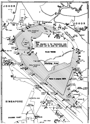

Reclamation works at Pulau Tekong will involve dredging, construction of revetment, soil investigation and soil improvement works. Soil improvement works will entail sand piling and deep cement mixing. Trailer-suction-hopper dredgers (TSHD) will be used for transporting and pumping sand into the working area. Safety boats will be deployed in the vicinity to warn other craft of the operations in the area. Further general enquiries relating to the project can be directed to Mr. R Kamata, the construction manager, at Tel: 9624 8603, email: ryuji_kamata@tjput.com.sg.
Subscribe to:
Posts (Atom)