Showing posts with label master-plan. Show all posts

01 April 2019

13 Apr (Sat): Visit the 2019 Draft Master Plan exhibition with Lepak in SG

Join youth volunteers from Lepak in SG on this visit to learn more and share your important feedback and suggestions!

The event is FREE but registration is required here https://tinyurl.com/lepak13apr

31 March 2019

Student ideas for developing Changi

I stopped by the public exhibition of ideas by students as part of the 2019 Draft Master Plan. Lots of interesting ideas, including some focused on retaining and enhancing terrestrial biodiversity. But there doesn't seem to be much consideration for impact on the marine biodiversity there.
I also took a quick look at ongoing and completed shore protection works, taking the route I did to check on the impact of the massive 300-tonne oil spill in the East Johor Strait in Jan 2017. The shores seem to be alright.

28 March 2019

Climate change in the 2019 Draft Master Plan

Under "Adapting to Climate Change", the Plan projects that "by the year 2100, Singapore’s temperature will rise by 1.4°C to 4.6°C and sea levels could rise by up to 1m. The intensity and frequency of heavy rainfall events are also likely to increase while conversely, dry seasons could become even drier."
Glad to see the role of greenery in reducing urban heat is supported. Hopefully, ecosystems can be more fully considered in mitigating flood risks and rising seas.

Pulau Ubin and northern shores in the 2019 Draft Master Plan

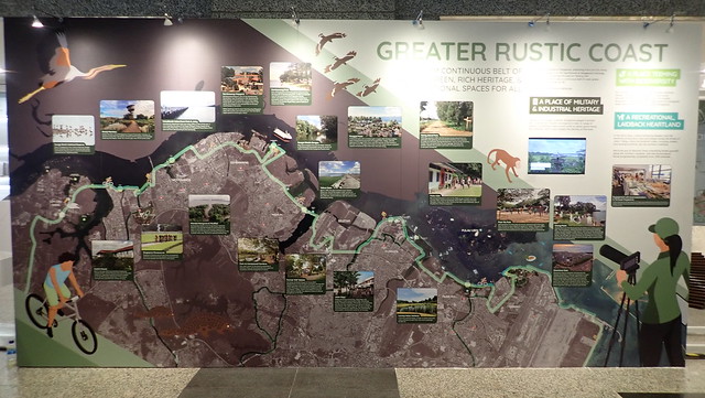
It appears the plan is for the northern coastline to remain rustic: from Sungei Buloh to Changi. It includes reassuring references to continued presence of wild mangroves at Pasir Ris and Khatib Bongsu; and Chek Jawa is mentioned as "one of Singapore's richest ecosystems".
Singapore Draft Master Plan 2019
Illustrative panel of the Greater Rustic Coast
at the Draft Master Plan exhibition. 
At Pulau Ubin, there is now no areas designated for agriculture use. But the reclamation profile on Pulau Ubin remains unchanged. And I remain worried about the Round Island Route which skirts close to the shoreline, particularly the area at the eastern tip of Pasir Ris Park and along the Changi coast.

Southern shores in the 2019 Draft Master Plan

Good to see that plans take into consideration the rich shores at Labrador Park and Berlayar Creek. There doesn't seem to be any planned reclamation in the South. Meanwhile, the maps have been updated with Singapore's first marine park.
from Urban Transformations>Greater Southern Waterfront

Kranji and Mandai shores in the 2019 Draft Master Plan

Good to see that the Plan reflects new extended Park area from Sungei Buloh to Lim Chu Kang. It also highlights the importance of Sungei Buloh Wetlands Reserve, the impending launch of Cashin House, as part of plans for the northern coastline to remain rustic: from Sungei Buloh to Changi.
Singapore Draft Master Plan 2019
Illustrative panel of the Greater Rustic Coast
at the Draft Master Plan exhibition. 
But the reclamation profile for Kranji and Mandai mudflats and mangroves remain unchanged.

Eastern shores in the 2019 Draft Master Plan

Plans for 'Changi City' may impact corals reefs and seagrass meadows that have settled on the artificial shores at Tanah Merah and East Coast Park. This shore is probably already impacted by massive new reclamation, currently ongoing.
But such plans may also be an opportunity to incorporate and nurture the amazing marine life that is already found there.

28 February 2014

Sharing an imagined Singapore 'Great Barrier Reef'

I was kindly invited to speak about natural regeneration on artificial shores and my wacky idea of imagining a Singapore ‘Great Barrier Reef’!
It was also exciting to learn about the science of natural regeneration on our artificial shores from Dr Karenne Tun talk's "Build it right and they will come". I really learnt a lot about coastal restoration at the Symposium on Climate Change Adaptation: Aquatic Invasives and Coastal Restoration.

26 November 2013

City in a Reef: my feedback on the Draft Master Plan 2013

Natural regeneration on Singapore's artificial shores and structures is already happening now. Unintentionally, with zero replanting.
A rich reef growing naturally at Tanah Merah Ferry Terminal, Jun 2013
Can we plan coastal works to allow reefs, mangroves and seagrasses to naturally regenerate? Naturalise canals leading to the sea for a continuum of freshwater wetlands to mangroves? Imagine what's possible! Reefs and natural marine ecosystems at our doorstep, for all in the City to enjoy.

Reefs on Singapore's artificial seawalls!

A reef has settled naturally on the artificial seawalls at Tanah Merah Ferry Terminal. A wide variety of corals and marine life can be found here.
A rich reef growing naturally at Tanah Merah Ferry Terminal, Jun 2013
More amazingly, these corals survived the massive oil spill of May 2010 and global coral bleaching in the same year that hit this stretch of shore! Can we encourage similar natural regeneration on other stretches of artificial seawalls and structures?! These details are part of City in a Reef: my feedback on the Draft Master Plan 2013.


Seagrasses on Singapore's artificial shores!

Lush seagrasses have grown naturally on the artificial shores at Tanah Merah!
Lush seagrasses with Tanah Merah Ferry Terminal
on the horizon. May 2013.
More amazingly, these seagrasses survived the massive oil spill of May 2010 that hit this stretch of shore! Lush seagrasses were also recently seen at artificial shores of East Coast Park, and have been seen in the recent past as well. Can we encourage similar natural regeneration on other stretches of artificial shores?! These details are part of City in a Reef: my feedback on the Draft Master Plan 2013.


Mangroves on Singapore's artificial seawalls!

Large mangrove trees have settled naturally on Pulau Hantu's artificial seawalls right next to massive petrochemical plants at Pulau Bukom.
Checking the mangroves on the Pulau Hantu seawall in Mar 2013
I also observed similar natural regeneration on artificial shores near the Marina Barrage in 2008. Can we encourage similar natural regeneration on other stretches of artificial seawalls?! These details are part of City in a Reef: my feedback on the Draft Master Plan 2013

21 November 2013

Pulau Ubin and northern shores in the Draft Master Plan 2013

What's new to me is the "Northern boardwalk" at Pulau Ubin. Also that the area managed by "Outward Bound Singapore will be opened up for organised visits".
It was reassuring to read that the planners acknowledge Pulau Ubin is "much beloved by Singaporeans" and "will remain as a rustic retreat". Coney Island Park is announced and it appears that there are no changes planned for Pasir Ris mangroves and Changi beach.

Southern shores in the Draft Master Plan 2013

The main changes to the Southern Island in the Plan include plans to build create a freshwater reservoir next to Pulau Brani and a new waterfront park at Keppel Island.
The original natural part of Pulau Semakau is now marked green in the Parks and Waterbodies Plan 2013 overlay. Otherwise, there doesn't seem to be much changes in the status of the Southern Islands and Western Islands.

Mandai mangroves in the Draft Master Plan 2013

An exciting development is the plan for Cashin House to become "a new visitor gateway to the western part of Sungei Buloh Wetland Reserve". The creation of Sungei Buloh Wetland Park has also turned  adjacent olive green space ('Open Space) into bright green ('Park') under NParks care.
While it's great to see an extension of area covered under the umbrella of the Sungei Buloh Wetland Reserve and Park, Mandai mangroves and mudflats remains designated a 'Reserve Site'.

31 January 2013

What shores will Singapore lose in 7-million population plan?

How will Singapore's shores be affected by plans for a 7-million population by 2030? The landuse plan by the Ministry of National Development released today shows some of the shores that may be lost.
These include Chek Jawa, Pulau Sekudu, Changi shores, Mandai mangroves and probably Pasir Ris mangroves too, if land reclamation (in yellow) plans goes ahead.