
 |
| Photos by Che Cheng Neo, Juria Toramae and Richard Kuah |
More about Pulau Semakau
Just as Changi Airport and Changi Beach are not the same even though they are near one another and share a name, Pulau Semakau is NOT the same as the Semakau Landfill. The Landfill was created by destroying all of Pulau Saking, and about half of the original Pulau Semakau by building a very long seawall. Fortunately, the landfill was constructed and is managed in such a way that the original mangroves, seagrass meadows and reefs on Pulau Semakau were allowed to remain. It is NOT true that the construction of the Landfill created the marine life found on Pulau Semakau. The marine life was there long before the Landfill was built.

What is the fate of this shore?
The 2013 landuse plan by the Ministry of National Development released in response to 2013 Population White Paper shows plans for 'possible future reclamation' (in light blue surrounded by dotted lines) that may impact the eastern shore of Pulau Semakau. More about the possible impact of the 2030 Landuse Plan on our shores.


Let's hope these shores will be spared this fate.
The Singapore Blue Plan 2018
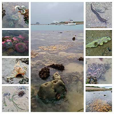
Pulau Semakau and nearby islands and submerged reefs have been recommended by the Singapore Blue Plan 2018 for Immediate Conservation Priority.
The Blue Plan recommends the intertidal and subtidal marine areas of Pulau Semakau and adjacent Pulau Hantu, and Pulau Jong to be designated Marine Reserve.
The Blue Plan highlights that Pulau Semakau and its associated patch reefs comprise many ecosystems: coral reefs, mangrove areas, intertidal sandflats, seagrass meadows, and coral reefs. The subtidal area of Pulau Jong is larger than the terrestrial area. Pulau Hantu is a popular dive site has seen increasing interest in the past decade due to biodiversity awareness. If protection is accorded to these three islands, zonation plans for use can be implemented to manage tourism and human impacts.
DOWNLOAD the Plan, SUPPORT the Plan! More on the Singapore Blue Plan 2018 site.
Full photo albums by the team
Richard Kuah
Juria Toramae
Che Cheng Neo
