What are the possible impacts of developments revealed in PM Lee's National Day Rally Speech last night?
 |
Amazing living reefs at Kusu Island, just 15mins
from the Central Business District, photo taken in Jun 2012. |
Although there is always a concern that developments may impact existing marine life, this is also an opportunity to consider construction that would encourage marine life to settle naturally on artificial structures.
According to today's
media articles of PM Lee's speech, most of what was revealed are not new. I could not find an online version of the PM's full speech, nor diagrams or charts of what actually will be affected. So this is just my best guess interpretation of information currently available.
Changi and Tanah Merah
Proposed developments at Changi include a new air base and a fourth runway at Changi East, Paya Lebar Air Base to be moved to Changi. This is not new as the Civil Aviation Authority of Singapore (CAAS) was
reported in Mar 2013 to be looking into the feasibility and benefits of a fourth runway.
The shores around this development are indicated on this Google Earth screen shot. It's not clear if these shores will be affected by Changi Airport developments.
 |
| Click on image for larger view. |
This includes the
regenerated coral reefs at Tanah Merah Ferry Terminal and
regenerating seagrass meadows at the artificial shores nearby, which are
easy for even kids to explore.
 |
Thick coral growths at Tanah Merah Ferry Terminal,
seen in Jun 2013. |
As well as the artificial sandy shores at Changi East which has since come to life with amazing marine life not commonly seen elsewhere in Singapore (because we have lost such large sandy shores that are seen at Changi East).
 |
Vast living sandy shores at Changi East aka "The Lost Coast"
during our last visit there in Dec 2012. |
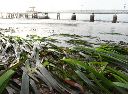
All along Changi from Changi Ferry Terminal to Fairy Point, there are narrow shores with seagrass meadows (which often show signs of
dugong feeding!) as well as rocky shores teeming with colourful sea fans, sponges and other marine life.
 |
Seagrasses near Changi Point with dugong feeding trails,
seen in Jul 2013. |
With the information currently available, it is not immediately clear if these developments will affect these shores.
Related links
"Southern Waterfront City"
PM Lee reiterated earlier announcements to consolidate all port operations in Singapore that are currently spread across Tanjong Pagar, Keppel, Brani and Pasir Panjang to Tuas, which will also free up space for developments.With the prime land in Tanjong Pagar freed up, Singapore can then build a new Southern Waterfront City, the size of 1,000 hectares or 2.5 Marina Bays, stretching “all the way from Shenton Way to Pasir Panjang, from the east all the way to the west.”
Indeed, the idea of a mega port at Tuas was proposed by the Government's Economic Strategies Committee in 2010 and the consolidation of port operations was announced in
Oct 2012 in which the city terminals at Tanjong Pagar, Keppel and Brani, plus those at Pasir Panjang will eventually be merged at Tuas. The port leases at Tanjong Pagar, Keppel and Brani will end in 2027. The mega port will be located at the hockey stick-shaped portion of
massive reclamation at Singapore's western tip which has been going on for years.
The Land Use Plan based on the Population White Paper included plans for a "Southern Waterfront City: In the longer term, a new southern waterfront city will extend from Marina Bay along the waterfront from Keppel Channel, through Telok Blangah to Pasir Panjang Terminal. After the relocation of the existing City Terminals and Pasir Panjang Terminal, 325ha and 600ha of water-front land will be freed up respectively. The land will subsequently be redeveloped to provide new commercial and housing developments."
The "Southern Waterfront City" echos a plan attributed to Mr Tay Kheng Soon who was
reported in Feb 2013 to have said that Singapore can accommodate a population increase of up to two million. And all two million would be housed on a 2,187ha swathe of land along the southern coastline, stretching from Pandan Reservoir in the west to the East Coast Park beach. Land where the Keppel and Marina Bay golf courses are currently sited would make way for housing, as would the port area once container port functions are consolidated in Tuas in the long term. Space around the Gardens by the Bay would cater to the super-rich, with homes built on the sea to entice those keen on waterfront living. Some parts of the south would also be for schools, offices and factories.
Among the interesting shores nearby include the rich slivers of shores at
Sentosa Serapong that like just opposite the container terminals at Brani.
And of course the natural shores on Sentosa's western tip which has seagrass meadows. The corals here were destroyed by the
Resorts World Sentosa reclamation near the cable car tower in 2007, and those near Rasa Sentosa were
badly impacted by the 2010 mass coral bleaching.
 |
Seagrass meadows near Underwater World Singapore
seen in Aug 2013. |
Unfortunately, on the natural the reef flats near Rasa Sentosa, the line of large blue drums set up as a security barrier are starting to break up as they batter the reef. Heng Pei Yan has done
a thorough review of the situation on her blog, showing how the layout of blue drums have changed over time, including video clips of how the wake from passing ferries cause the drums to bash against the intertidal reef flat at low tide, and on the high shore, rocks battered by the blue drums and how a shattered blue drum is leaking foam all over the shore.
 |
Photo by Heng Pei Yan of blue drum breaking up
in Aug 2013. |
Labrador shore, which has Singapore's last mainland reefy, seagrassy, rocky shores in the South, is still hanging on despite severe impacts to its reefs following developments for the new Pasir Panjang Container Terminal which has been going on for years. This includes massive
reclamation,
dredging and
underwater blasting. The shore was also impacted by a
huge trench dug into it (called a cofferdam) to relocate service pipelines to Pulau Bukom.
 |
| Seagrasses still hanging on during my last trip here in Jan 2013. |
Then, there is the amazing Cyrene Reef, a 1km long submerged reef which has Singapore's best seagrass meadows studded with humungous sea stars, as well as colourful coral reefs, even though it lies in the
middle of an industrial triangle.
Once again, with the information currently available, it is not immediately clear if these developments will affect these shores.
Related links
Can artificial shores support natural marine life?
Yes! This stunning reefscape is growing on artificial pontoons at
Marina Keppel Bay and can be easily seen even from above water! This suggests that we should seriously consider allowing nature to be a part of coastal development.
Our artificial seawalls can also provide places for reefs to settle and grow naturally. The most amazing example of this is of course the reef at Tanah Merah Ferry Terminal. Kok Sheng was the one who first shared
a closer look a them. Among the hard corals seen here are large colonies of delicate branching and plate-forming corals. As well as less common species such as
Lettuce coral (
Pavona sp.),
Horn coral (Hydnophora sp.) and even rarer species such as
Cabbage coral (Trachyphyllia geoffroyi).
Even mangroves can settle naturally on our artificial seawalls! This has happened at Pulau Hantu with a wide variety of mangrove species settling all on their own without anyone planting them there. This includes the less common
Bakau pasir (
Rhizophora stylosa)! These trees are tall and very healthy, producing lots of propagules that can grow up to become more mangrove trees! More in
this post and more photos in
this set.
 |
Mangrove trees growing on the artificial seawall
Pulau Hantu have grown so tall! In Mar 2013 |
While lush seagrasses have settled in the sandy lagoon behind the artificial seawalls at Tanah Merah Ferry Terminal! This is the larger of the two patches of
Smooth ribbon seagrasses (
Cymodocea rotundata). So far, the only other places where this species of seagrass is found are Chek Jawa and Cyrene Reef.
More about amazing marine life that we have already encountered on Singapore's artificial shores in
this old post.
Natural protection!
Not only are these marine ecosystems beautiful, but they can also play a role in
protecting the shores from coastal flooding and rising seas.
Need to protect the mothers!
For natural regeneration to take place, it is important to protect existing natural sites as a continual source of marine life ‘babies’ and plant seeds and seedlings.
Wouldn't be it great if these aspects could be considered in development plans that impact Singapore's shore?