But should the volume of traffic double in the busy and narrow Straits, as it is expected to by 2024, it will take vessels an extra hour - eight hours instead of seven - to get through the waterway. It will also become less safe.
The second phase of the study will examine how navigational safety in the strait can be improved through "physical, operational and technological adjustments".
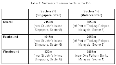
Here are the narrowest points in our water ways as indicated in the working paper by SimPlus Pte. Ltd., Singapore on SG Press Centre.

The Traffic Separation Scheme (TSS) that runs along the straits of Malacca and Singapore, between One Fathom Bank off Port Klang in the west and Horsburgh Lighthouse in the east, is about 250 nautical miles long. The narrowest point in the TSS, along which international shipping travels through the straits, lies just south of St John's Island within the Singapore Strait and measures 530m westbound, 1,617m eastbound and 2,150m overall in width.
The second phase of the study will examine possible measures that can enhance the carriage capacity of the Singapore Strait while at the same time maintaining navigational safety. These include electronic navigation and the Marine Electronic Highway (MEH).
The shipping situation in the narrow Straits is currently compounded by the flotilla of "container ships languishing off the Singapore coast" due to the financial crisis, as reported in May 09 by Passport of the Foreign Policy blog.

Full media articles on the wildsingapore news blog.

