We surveyed a wide area on this trip and here's what we saw.
We started on a long loop around the Southern Islands. This is Pulau Salu, among our few undeveloped islands. It has a nice reef flat and there are several submerged reefs nearby too. Here's what Jeffrey and Chay Hoon shared from their dives at Salu.
Next to Salu is Pulau Sudong, one of the three islands within the Life Firing Range and unsurprisingly, there were jets flying overhead the island.
We were distracted for a while by their flying maneuvers!
The Sudong Anchorage nearby is designated for 'explosive' vessels. There were two LNG carriers and many other large vessels anchored there.
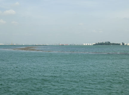
Next, the intriguing Pulau Pawai which does not have seawalls built around it and much natural shores and mangroves.
Here's a view of the Pulau Pawai from Google Earth, see the huge extent of the surrounding reefs and submerged reefs nearby. As well as the natural mangroves and coastal forest areas.
Next to Pulau Pawai is another relatively undeveloped island Pulau Senang. Although the centre part of the island is scarred by life-firing exercises, it too is surrounded by wide reefs, and natural coastal vegetation.
To the south of Pulau Senang, are tiny Pulau Biola and Raffles Lighthouse, the southernmost point of Singapore. An MPA vessel was at this location making sure everything was ok.
Here's a closer look at it. This is apparently the vessel used to spray the dispersants on oil spills. They are red and named 'Api Api'. I've often seen several of them berthed near West Coast Pier and wondered about their function.
Here is the vessel with Pulau Senang and Pulau Pawai in the background.
Jeff points out some places near Raffles Lighthouse where we had a closer look at the water quality. Raffles Lighthouse has among our best reefs. Here's what Jeff and Chay Hoon shared from their dives there. Jeff's photos also include some sightings at Pulau Biola nearby.
We spent a bit of time here scrutinising the water and the shores nearby. Jim spots a sea turtle! As usual, this creature is at the surface only briefly so no one got a photo of it.
The water looks clear and we could hardly see any slick.
We had a look at the seawalls on Raffles Lighthouse, they seemed normal.
A closer look at the seawalls, no signs of black tar or oil.
Circling around to the front of this picturesque lighthouse, we had a closer look (through the zoom lens) of the shore line in the sandy bay there.
Seems clear of oil slicks and tar so far. The upper tideline seems normal.
The seawalls on this side of the Lighthouse also seems clear.
Just off Raffles Lighthouse is the tiny and lush Pulau Biola.
The natural rocks on Biola looks clear. This tiny island is draped with lush growths of the Critically Endangered Pelir musang (Fagraea auriculata). This rare plant is found in only two other locations: Lazarus Island and Pulau Tekukor.
We then head towards Raffles Reserve Anchorage where the stricken vessel has been anchored.
Wow, it looks like it was rammed on the side. With damage to containers and the side of the ship.
There were lots of vessels nearby including one labelled "Pollution Control".
Here's a row of the various vessels next to the big ship. Behind it was another 'Api Api'.
The ship was encircled with boom, which seems to have been drawn up close to it. Perhaps the leak has stopped?
Here's more high-res photos of the stricken vessel.
We then head off to the waters near Pulau Semakau and the Semakau Landfill. There is a fish farm located in the area, which is said to be the largest fish farm in Singapore. I wonder how they have been impacted not only by the oil spill, but also the dispersant introduced to deal with the spill. It must be a blow to the farm, coming so close to Lunar New Year when they must surely be expecting to sell a lot of fish locally.
Here's a view of the natural shores of Pulau Semakau draped with mangroves and ringed by reefs. The Semakau intertidal is regularly monitored by TeamSeagrass, so we should be able to track any impact through that effort. The wooded area on the horizon is Pulau Hantu. The volunteers of the Hantu Bloggers dive there regularly and they will be checking up on this shore on the next dive.
The brown ring around Pulau Semakau is NOT oil! It's lush growths of Sargassum seaweed (Sargassum sp.) which is in season now.
A look at the seawalls of the Semakau Landfill, no obvious signs of spill.
Jeff then directs us to have a quick check on the Sisters Islands, where some of our best reefs are found. The water seems clear.
We also had a quick look at the marvellous natural rocky shore on St. John's Island.
A special tree on this coast is the rare Nyireh (Xylocarpus rumphii). I've not seen this tree from the sea. How magnificent the mother tree looks! Oil spills will not only affect marine life but also rare trees such as these. Jeff and the volunteers of the Blue Water Volunteers conduct regular surveys of our reefs, including those we visited today, so they will be able to continue to monitor any impacts.
There are many issues that can impact our shores. Everyone who loves our shores need to work together to learn about and protect them.
For this documentation trip, the rest brought alarmingly long lenses. Just my bad luck that my favourite Big Cam is in the hospital for three weeks having major injuries repaired. Fortunately, standby Big Cam works! Even though I haven't used her for years. Hurray!
After working hard on documenting, we head back to the cabin to enjoy some snacks. Oh dear, we have had a little accident too. Someone sat on the snacks.
Sivasothi had earlier initiated a plan for volunteer mobilisation during an oil spill. This is based on our experience during the May 2010 oil spill, to be better prepared for the next one. Here's Siva briefing on the plan last year.
Today's collaborative survey following the 4 Jan 2012 oil spill is a good result of Siva's plan! Thanks to Liang Jim and Jeffrey Low for inviting Siva and me on this survey. And it was great to catch up with Collin and Hui Ping too.
We'll need to keep a closer eye on the situation just to be sure, but it's a relief to see that there doesn't seem to be major impact so far.