
 |
| Photo thanks to Jason Ooi |
I'm repeating this series in November. More details soon. Please join us if you can.
There's easy access off the PCN down a short seawall. But still, be careful going down as rocks can be slippery.


 |
| Photos by Rui Quan Oh |
 |
| Photos by Rui Quan Oh |
More amazing sightings shared by Han Ping Lim. From rare sand dollar and Ramose murex, to fishes and other cool critters.

The babies of these corals are from Singapore reefs! This chart shared in the Long-Term Plan Review shows coral larvae (babies) dispersal in our waters from mass coral spawning. This highlights the importance of protecting our 'mother reefs' so that they can continue to produce babies that settle all along our shoreline.

What is the fate of these shores?
These shores lie west of Tanah Merah Ferry Terminal and are slated for massive reclamation outlined recently in the Long-Term Plan Review.
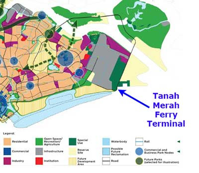 This shore will also be affected by plans for Long Island.

These shores lie west of Tanah Merah Ferry Terminal and are slated for massive reclamation outlined recently in the Long-Term Plan Review.

Preparatory works for Long Island will involve removal of seabed obstructions, construction of temporary sand bunds and sand infilling. Phase 1 will begin end-2026, while Phase 2 will take place after the end of the SEA Games 2029.

Along the way to the shore, we saw some signs of work. This one is apparently part of the Preparatory Work for Long Island. We also saw trees marked with tape. Usually a result of some survey which might affect them.


See these and other East Coast shores for yourself!
It's fun and easy to explore these shores. Come see these shores before they are gone! More details in East Coast Park - Surprising intertidal adventures for the family.
It's fun and easy to explore these shores. Come see these shores before they are gone! More details in East Coast Park - Surprising intertidal adventures for the family.
 |
| This is what the corals looked like during a very low tide in May 2021 before the mass coral bleaching and oil spill impact in 2024. |
Natural regeneration on Singapore's artificial shores and structures is already happening now. Unintentionally, with zero replanting. Can we plan coastal works to allow reefs, mangroves and seagrasses to naturally regenerate? Naturalise canals leading to the sea for a continuum of freshwater wetlands to mangroves? Imagine what's possible! Reefs and natural marine ecosystems at our doorstep, for all in the City to enjoy. More about this idea in my feedback to the Draft Master Plan 2013.
The Singapore Blue Plan 2018
Check out the Sinapore Blue Plan 2018 which outlines community recommendations for all these shores. DOWNLOAD the Plan, SUPPORT the Plan! More on the Singapore Blue Plan 2018 site.
More photos by others on the field trip
Rui Quan Oh
Han Peng Lim
The Singapore Blue Plan 2018
Check out the Sinapore Blue Plan 2018 which outlines community recommendations for all these shores. DOWNLOAD the Plan, SUPPORT the Plan! More on the Singapore Blue Plan 2018 site.
More photos by others on the field trip
Rui Quan Oh
Han Peng Lim
