

As usual, the rest of the team make all the special finds. Thanks to them for going all the way to the westernmost end of the shore. There is a canal there which also has interesting life. Kok Sheng saw an Estuarine moray eel, special sea stars and anemones, as well as other animals commonly seen on our northern shores. But the diversity is much lower than our previous surveys in Mar 2020 and Sep 2020.
.jpg) |
| Collage of photos by Loh Kok Sheng Link to his album at the end of this post. |
.jpg)
I had a quick look at the plants on the high shore. There were some common mangroves, a few tall trees, and smaller ones tucked among the Sea hibiscus thickets. As well as common shore plants. I was delighted to see the furry white jumping spider that is often seen in mangroves.
.jpg) There were still patches of lush Spoon seagrass (large and small leaves) along the shore, somewhat to our last survey in Sep 2020 and Mar 2020. Towards the western end where it is sandier, the patches were more sparse. The shoreline is very soft and silty in most parts. I didn't see any dugong feeding trails today, the tide wasn't very low and most of the low water line was trampled by people. The last time I saw them here was on our survey in Jul 2017.
There were still patches of lush Spoon seagrass (large and small leaves) along the shore, somewhat to our last survey in Sep 2020 and Mar 2020. Towards the western end where it is sandier, the patches were more sparse. The shoreline is very soft and silty in most parts. I didn't see any dugong feeding trails today, the tide wasn't very low and most of the low water line was trampled by people. The last time I saw them here was on our survey in Jul 2017.
.jpg)
.jpg)
.jpg)
I was relieved to see that the trash load at the low water mark was quite low (compared to the past), in most of the shoreline within NParks jurisdiction. But closer to the western end of NParks jurisdiction, the trash load was as I had observed in the past, quite high. Lots of trash also still accumulated on the high shore that is under the Commando jurisdiction. This evening, a large group of enthusiastic young people were out on the intertidal facing the Commando land, collecting trash to the happy sounds of music.
.jpg)
.jpg)
What is the future for this shore?
The western edge of this shore is close to the area where JTC plans to reclaim about 49ha of land off Lorong Halus to "meet future demand". No date has been set for the reclamation. JTC said: “To enhance the biodiversity in the area, nature-based solutions will be assessed for suitable locations within the reclamation site. “Solutions being studied include creating a gentler shoreline slope or increasing its roughness and number of crevices to encourage intertidal and marine biodiversity growth.”


 |
| Little dots around P. Ubin and off Pasir Ris are locations of current fish farms. |
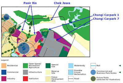
What is the long term fate of Pasir Ris shores?
There doesn't seem to be a change in 2013 plans to reclaim all of Pasir Ris, all of Changi from Carpark 1 to Carpark 7 and beyond, and reclaim Chek Jawa and Pulau Sekudu. These appear to remain in place in the Long-Term Plan Review. Including plans for a road link that starts at Pasir Ris, crosses to Pulau Ubin, right across Chek Jawa to Pulau Tekong, and back to the mainland at Changi East.
See Pasir Ris shores for yourself!
These shores are easy to get to, and enjoyed by many people. But it remains rich in a variety of marine life. More details in "Pasir Ris - Perfect intertidal getaway for the family" Today, it was heartwarming to see families with kids exploring the shore. There were also fishermen with line and rod, casting nets and kayak fishing.

There doesn't seem to be a change in 2013 plans to reclaim all of Pasir Ris, all of Changi from Carpark 1 to Carpark 7 and beyond, and reclaim Chek Jawa and Pulau Sekudu. These appear to remain in place in the Long-Term Plan Review. Including plans for a road link that starts at Pasir Ris, crosses to Pulau Ubin, right across Chek Jawa to Pulau Tekong, and back to the mainland at Changi East.

See Pasir Ris shores for yourself!
These shores are easy to get to, and enjoyed by many people. But it remains rich in a variety of marine life. More details in "Pasir Ris - Perfect intertidal getaway for the family" Today, it was heartwarming to see families with kids exploring the shore. There were also fishermen with line and rod, casting nets and kayak fishing.
Photos by others on the survey
Loh Kok Sheng
Zen Xuan He
Yan Le Su