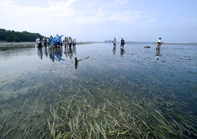
There is a patch of long Tape seagrass growing at Sentosa Palawan! A nice surprise to see on an artificial beach and 'islet' facing the busy port! Sentosa is indeed a precious refuge for seagrasses and rare mangrove trees.
Over the weekend, the survey team and I also checked out the Great Sentosa exhibition at Vivocity. Once completed,
Greater Sentosa is projected to attract about double the current 17 million visitors a year. I do hope our marine life will be given a chance to be a part of this Greater Sentosa. So hopefully it won't come to a point where we can only see Sentosa's rare plants and animals in a glass jar.
More of my thoughts on Greater Sentosa at the end of this post. Which I have submitted as my feedback to the Greater Sentosa masterplan. Submit your feedback too here
https://form.gov.sg/6a44c40969c66ca0ff78bbc6I saw the long Tape seagrass in the narrow channel that remained flooded at low tide, between the main island and the islet. I surveyed while the rest of the team checked out
Terumbu Buran.
The patch was not extensive or very dense, but it just warms my heart to see long Tape seagrass. I couldn't see any that were flowering though.
The Sentosa Palawan seagrass is a pale shadow, but reminds me the vast beds of Tape seagrass at Pulau Semakau that grew in a kind of shallow lagoon between the high shore, and the reef edge. Since the 2010s, all the Tape seagrasses at Pulau Semakau, Cyrene and other southern shores got cropped and never recovered since.
Surprisingly, the only Tape seagrass that remain long today are mostly found on artificial shores: Seringat Kias, East Coast Park B and PCN, Tanah Merah Ferry Terminal. Long Tape seagrass also remain at Sentosa Tg Rimau (probably the largest meadow of long Tape seagrasses that remain today), as well as at Labrador. These seem quite resilient and survived the 2024 Pasir Panjang Oil Spill!
Other than Tape seagrass, I didn't see much else at Palawan. There were some fishes swimming among the seagrasses. On the sandy shore, the usual signs of Sand bubbler crabs, Ghost crab, and lots of Bazillion snails.
What is the fate of Sentosa shores?Sentosa Tg Rimau is among our last natural cliffs with rare trees, reefs and probably the largest meadow of long Tape seagrasses that remain today.
This shore will be impacted by efforts to stabilise the slope. And the deployment of
"a few hundred" one-tonne concrete blocks (XblocPlus) “at the toe of the slope to mitigate wave erosion".
The other rich shore on Sentosa is at Serapong. The first phase of the Greater Sentosa begins with the construction of a transport hub linking Sentosa and Pulau Brani in Keppel Harbour. The timing of this phase has yet to be decided. But Brani Port Terminal currently on Pulau Brani are expected to move to Tuas in 2027. These transport hub plans are very close to the last remaining wild reefs at Serapong shores - among the best near the mainland. Wouldn't be great if the plans could allow people to see the reefs at Serapong (yellow area), and allow mangroves to settle naturally on Brani (blue area).
Here's what the team saw in the yellow area in
Apr 2026. We surveyed the entire Serapong in
Jun 2026.
Hopefully, the development on Brani can make the reefs on Serapong a feature and not a bug? So people using the people mover to cross from Brani to Sentosa can view the corals on Serapong the same way that people using Tanah Merah Ferry Terminal can see the corals that settled naturally on the seawall there.
On the Brani side of the seawall (blue area), perhaps mangroves can be encouraged to settle naturally on the seawall? The way they have done so at Pulau Hantu, without any planting or need to care for them. The Hantu mangroves come in a wide variety including
possibly one Nyireh laut! At the exhibition, we saw a live young Nyireh laut which the talented Sentosa horticultural team have propagated. How amazing it would be to replant them on Brani as well!
Wouldn't it be great if Brani and Sentosa shores can become a mother shore to allow natural regeneration when major reclamation and coastal protection is implemented nearby.
Reclamation at Keppel-Tanjong Pagar expected to start end of 2027.
And there are long terms plans such as the
Greater Southern Waterfront coastal protection plan - a “continuous line of defence” at the South. Construction is slated to begin in the 2030s.


.jpg)
.jpg)
.jpg)
.jpg)
.jpg)


---small.jpg)
---small.jpg)


